Why Geography Still Matters in Our High-Tech World
Published:
What is Geography, Really?
When most people hear the word geography, they think of maps, countries, or maybe memorizing capital cities back in school. But geography is far more than that — it’s a dynamic, interdisciplinary field that helps us understand the world and our place in it.
What the Experts Say
According to UNESCO
Geography is the study of the relationships between people and their environments, encompassing both the physical properties of Earth’s surface and the human societies spread across it.
According to the National Geographic
Geography is the study of places and the relationships between people and their environments.
So, What is the Geography, Really?
Both definitions highlight the idea of relationships. These include relationships between people and places, environments and decisions, as well as systems, patterns, and outcomes.
Thus, geography allows us to ask deep questions:
- How do trade routes influence a country’s economic development?
- Why are some coastal areas more vulnerable to hurricanes than others?
- What are the connections between a community’s water supply and its agricultural practices?
To illustrate this further, influential geographer Yi-Fu Tuan stated:
Geography is the study of the earth as the home of people.
It’s a beautiful reminder that geography is not only analytical, but also human-centered. It helps us think about home, identity, migration, inequality, and sustainability.
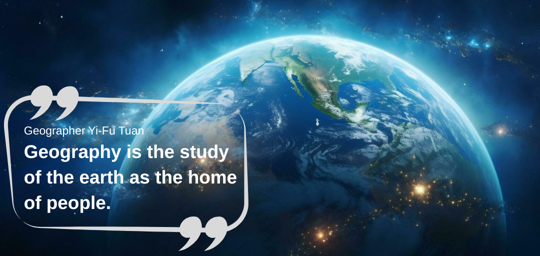 Fig 1. Geographer Yi-Fu Tuan’s definition of geography
My Perspective - An AI Researcher with a Passion for Geography
From my perspective, geography is the “science of space and connection.” It examines how the physical world and human behaviors intertwine across space and time.
In the high-tech era, geography provides the spatial lens we need to:
- Interpret big data
- Detect patterns and inequalities
- Design better systems for cities, energy, health, and resilience.
This is why I started this blog. To truly understand the potential of GeoAI — the fusion of geography and artificial intelligence — we must first appreciate the essential, powerful role that geography continues to play in shaping our world.
Why Geography Still Matters Today?
Unlike an old-fashioned school subject, geography is the center of the world’s most trending challenges and our most innovative technologies. It is the science that connects climate models to coastal communities, urban planners to megacities, and satellites to the phone in your pocket. Thus, geography still matters because where things happen has never been more important.
Let’s explore several pressing issues facing our planet.
Climate Change: Mapping an Uneven Crisis
Climate change doesn’t affect all places equally.
Low-lying nations like the Maldives or Kiribati face the very real possibility of disappearing under rising seas. The Arctic is warming roughly four times faster than the global average (NOAA, 2023), reshaping ecosystems and livelihoods. In drought-prone regions of sub-Saharan Africa, shifting rainfall patterns pose a significant threat to agriculture, leading to migration and exacerbating food insecurity.
Geography equips us with the tools to:
- Map the most vulnerable areas
- Model future scenarios under different emission pathways
- Support adaptation strategies that protect people and ecosystems
As the IPCC warns, without urgent adaptation, over 1 billion people in low-lying coastal zones could be at risk from flooding by 2050. Understanding the spatial distribution of these risks is the first step to protecting communities.
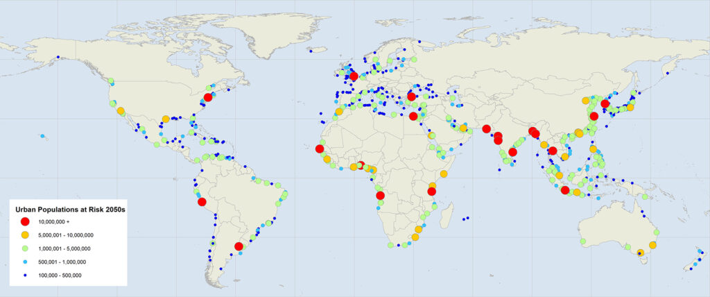 Fig 2. Cities at risk from sea level rise
Urban Growth: Designing Smarter Cities
Cities are expanding at a breathtaking pace.
By 2050, the United Nations predicts that 68% of the world’s population will live in urban areas. This growth brings opportunities - economic hubs, cultural exchange, and innovation - but also enormous challenges.
Without smart planning, cities risk:
- Urban sprawl that eats up farmland and green space
- Infrastructure strain as transport, water, and energy systems struggle to keep up
- Spatial inequality, where some neighborhoods thrive while others lack even basic services
In this context, geography transcends academic theory to become a practical toolkit for creating livable, sustainable cities. Urban geographers and planners leverage spatial analysis to design efficient transportation networks, distribute resources equitably, and implement green infrastructure that both cools overheated neighborhoods and manages floodwaters.
https://www.youtube.com/watch?v=wHe2OSaq_ds
Everyday Life and Technology: Geography in Your Pocket
Beyond global crises, geography shapes our daily lives in countless subtle ways.
Every time you check the weather, order food, call a ride, or navigate to a new coffee shop, you are using geographic technology. GPS navigation apps like Google Maps, food delivery platforms like Grab, and even augmented reality games all depend on geospatial data and location-based algorithms.
Without geographic principles, these systems simply wouldn’t work. And as AI makes these tools smarter - predicting traffic jams, optimizing delivery routes, or tailoring local recommendations - geography becomes the invisible backbone of the tech we take for granted.
Personally, whether we are mentioning the climate crisis, designing cities of tomorrow, or building the applications that guide our daily lives, geography remains indispensable. It is the lens that reveals patterns, highlights inequalities, and connects the dots between global trends and local realities.
Geography + AI: A Powerful Combination
Geography helps us ask profound questions, while artificial intelligence gives us unprecedented new ways to answer them.
Thanks to advances in machine learning, natural language processing, and computer vision, we can now process vast amounts of geographic data faster and more accurately than ever before. This fusion, often called GeoAI, combines the spatial thinking of geography with the pattern-recognition power of AI — opening doors to solutions we couldn’t imagine a decade ago.
From Satellites to Insights
Every day, Earth observation satellites capture terabytes of imagery. And these images are just pixels, but they become powerful tools with AI.
- Deforestation detection: CNN (convolutional neural networks) can scan satellite imagery to identify illegal logging in the Amazon, often before human inspectors can detect it.
- Mining monitoring: AI models can track unauthorized mining operations that threaten ecosystems.
- Urban change detection: Automated systems can flag new construction or informal settlements in growing cities, helping planners respond more quickly.
Example: Google Earth Engine already enables large-scale geospatial analysis, and when combined with AI models, it can generate actionable environmental intelligence in hours instead of weeks.
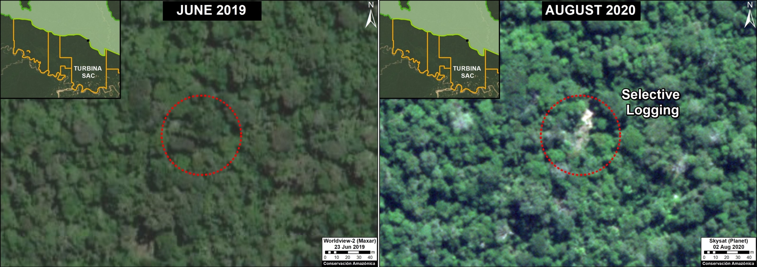 Fig 3. Detecting illegal logging with satellites
Understanding Human Signals with NLP
Geographic data isn’t just physical, it’s also social. During natural disasters, people turn to X, Facebook, and news outlets to share what’s happening.
- Crisis mapping: NLP systems can extract location references from thousands of social media posts.
- Sentimental analysis: Track public mood during environmental events, like wildfires or floods.
- Rumor detection: Identify misinformation spreading in disaster zones so authorities can respond.
Example: The CrisisNLP project uses AI to process massive social media data during emergencies, helping responders prioritize aid.
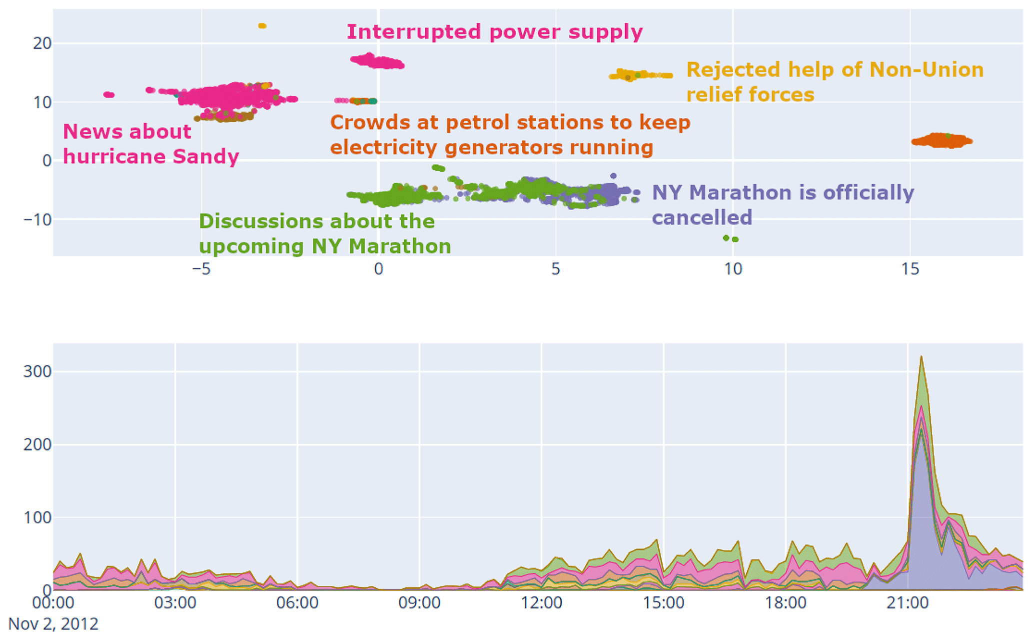 Fig 4. Crisis mapping from social media data
Why GeoAI Excites Me
GeoAI is more than just a technical breakthrough — it’s a way to make our understanding of the planet actionable. It’s where my background in AI meets my curiosity about the spatial patterns that shape our lives.
From fighting climate change to building smarter cities, GeoAI has the potential to transform how we respond to the world’s biggest challenges. And it’s not just for scientists or governments - as technology becomes more accessible, these tools can empower journalists, activists, and local communities to make better decisions.
Let’s Explore Together
Starting this blog is my way of sharing the excitement I feel when geography and AI come together to reveal the hidden patterns of our world. I want it to be a space where curiosity thrives, where we learn from each other, and where complex ideas become clear and inspiring.
If you’re as fascinated by the Earth as I am — or just curious about how AI can uncover its secrets — you’re in the right place.
The best journeys are the ones we take together.
So, buckle up! This is just the first step, and I can’t wait to explore with you.
What should we explore next? 🚀
Got a Artificial Intelligence, Geography, or GeoAI topic you’re curious about, or something in this post you think could be clearer or sharper? Drop your thoughts in the comments — I’m all ears. Let’s make this blog a two-way conversation.
Author: Felix Do